If you want to know why China wants control of the South China Sea – and why the U.S. and other nations may go to war to stop them – then take a look at this map.
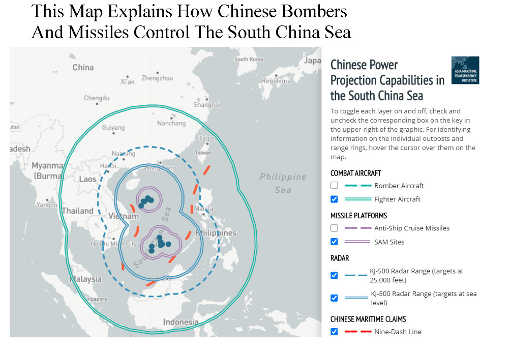
A U.S. think tank has put together an interactive map of how Chinese air, missile and radar bases in the disputed South China Sea enable Beijing to project military power as far away as Singapore, Vietnam, and Indonesia. The map, compiled by the Center for Strategic and International Studies, depicts the ranges of Chinese weapons and radar deployed on various small islands and reefs in the South China Sea.
For example, clicking on the map’s Bomber Aircraft tab shows that Chinese H-6 bombers based on Woody Island – about 400 miles from Hong Kong — could strike targets far to the east of the Philippines, and as far south as Singapore, the vital shipping routes through the Strait of Malacca, and Indonesia’s capital Jakarta. China’s J-11 fighters could reach as far as Singapore, Balikpapan, and the Java Sea, as well as to the east of the Philippines. Southern Vietnam and Malaysia would be well within range of Chinese airpower.
Chinese anti-ship and anti-aircraft missiles deployed on the Spratly Islands — a cluster of tiny reefs in the middle of the South China Sea – could also cover a vast swathe of territory, according to the CSIS map. From Mischief Reef — about 900 miles southeast of Hong Kong and about 500 to 600 miles from Manila and Ho Chi Minh City –YJ-62 and YJ-12B anti-ship cruise missiles can strike as far as the Vietnamese coast, Brunei and the Philippine island of Palawan. HQ-9 surface-to-air missiles will cover the airspace around the Chinese-held islands and reefs.
While Chinese air and missile bases tend to receive the most attention, the CSIS map conveys a vital point: the South China Sea provides an indispensable platform for the radars needed to find targets for those warplanes and missiles. From airbases on Woody Island and Mischief Reef, Chinese KJ-500 airborne early warning aircraft can spot high-flying aircraft all across Vietnam, and as far as Manila and Tarakan. The KJ-500s can detect ships sailing along the Vietnamese coast, Brunei and Palawan.
Greg Poling, a CSIS Asian affairs expert, says the map shows the importance of the South China Sea for projecting Beijing’s power in the region. “If China didn’t have facilities in the Spratlys, it wouldn’t be able to put patrol aircraft and fighter jets over the Strait of Malacca or Indonesia without aerial refueling or using an aircraft carrier in the future,” Poling tells me.
The South China Sea, rich in energy resources and located near busy shipping lanes, has been disputed for decades. China, Vietnam, the Philippines, Taiwan, Indonesia, and Malaysia all have competing claims on the area, while the U.S. is loath to let China control waters dear to so many American allies.
Poling believes that China’s numerous bases boost Beijing’s chances of controlling the South China Sea. “The major benefit of China’s facilities right now is the ability to monitor all activity in the South China Sea and support forward deployment of coast guard and militia ships who can rapidly respond to any activities by the Southeast Asian parties that China doesn’t like,” he tells me.
“That’s slowly pushing the Southeast Asians out of these waters. If that strategy continues to work as well as it has been, China will control the South China Sea in a few years without having to fire a shot. And it will undermine any support for U.S. forward presence—after all, why should the Philippines or other partners support U.S. forward deployments if those aren’t doing them any good?”